Some changes are organic, others planned. The transformation of Toronto’s Regent Park falls under the latter category. The neighbourhood — one of Canada’s first social housing projects and its largest as well — is the site of an ongoing three-phase revitalization including new condos and community amenities alongside affordable housing units. The revitalization, which began in 2005 and is a partnership between Toronto Community Housing and The Daniels Corporation, seeks to reconnect the neighbourhood, bordered by River Street, Queen Street East, Gerrard Street and Parliament Street, to the rest of the city.
Previously, Regent Park residents had been cut off from the city, as planners in the late ’40s opted to take homes off main streets, instead facing them against each other. “At the time, cities had a negative connotation,” said Heather Grey-Wolf, Toronto Community Housing’s development director, explaining what influenced Regent Park’s original layout.
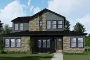
Now, with the final redevelopment phases underway, we’ve compared shots from just before Regent Park was built in 1948 right up to the present day. All contemporary photos are by James Bombales. Historic photos are courtesy of the City of Toronto Archives, Toronto Public Library, and Steven Hoang.
335-337 Parliament Street, 1947


Queen Street East, looking west from Queen Street Bridge, 1907


Gerrard East looking east from Parliament, ca. late 80s/early 90s


Parliament St. north of St. David St., 1953


64 Regent Street, 1952


Dundas Street Firehall, 1956


Reinhardt Brewery Company, 1957


Queen Street Bridge from Bayview Avenue, 1952


Regent Park Aquatics Centre, 2011


Historical photo by Steven Hoang
River Street near Dundas Street, 2014


Historical photo by Steven Hoang
This Regent Park then-and-now is part of our ongoing series that’s covered notable Toronto areas and landmarks including Mimico and New Toronto and Ossington Avenue and Trinity Bellwoods.