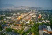
The Junction is defined by the trains that border the industrial neighbourhood in Toronto’s west end. This part of the city has some remarkably well-preserved Victorian storefronts and yes, you can still hear the trains rush past along its perimeter even though the area is now more known for its boom in coffee shops and restaurants than its factories.
We found historic photos that show the past of Keele and Dundas and followed Keele Street down to Bloor Street West and Old Weston Road up to St. Clair. See how the historic pictures match up with their current counterparts in our interactive slider. All present day photos are by James Bombales. All historic photos are from the Toronto’s Public Library’s Digital Archive unless otherwise specified.
Dundas and Keele, looking west, 1923


Photo: City of Toronto Archives, Series 71, Item 2815
Heydon House, Old Weston Road and St. Clair, 1955


Southeast corner of Keele and Junction Road, 1926


Photo: City of Toronto Archives, Series 372, Item 1103
Keele and Dundas Street West, looking north, 1912


Photo: City of Toronto Archives, Fonds 1231, Item 430
Bloor and Keele, looking east, 1915


Photo: City of Toronto Archives, Fonds 1231, Item 2205
Annette Street Library, 1915


Dundas, east of Mavety Street, 1923


Photo: City of Toronto Archives, Series 71, Item 2864
Keele and Junction Road, 1953


For more sliders of Toronto neighbourhoods, check out our photo tours of Ossington, Dufferin Street, Midtown Toronto, Roncesvalles, Yorkville and Spadina.